
The first volume of the Civitates Orbis Terrarum was published in Cologne in 1572. The sixth and the final volume appeared in 1617.
This great city atlas, edited by Georg Braun and largely engraved by Franz Hogenberg, eventually contained 546 prospects, bird’s-eye views and map views of cities from all over the world. Braun (1541-1622), a cleric of Cologne, was the principal editor of the work, and was greatly assisted in his project by the close, and continued interest of Abraham Ortelius, whose Theatrum Orbis Terrarum of 1570 was, as a systematic and comprehensive collection of maps of uniform style, the first true atlas.
The Civitates, indeed, was intended as a companion for the Theatrum, as indicated by the similarity in the titles and by contemporary references regarding the complementary nature of two works. Nevertheless, the Civitates was designed to be more popular in approach, no doubt because the novelty of a collection of city plans and views represented a more hazardous commercial undertaking than a world atlas, for which there had been a number of successful precedents. Franz Hogenberg (1535-1590) was the son of a Munich engraver who settled in Malines. He engraved most of the plates for Ortelius’s Theatrum and the majority of those in the Civitates, and may have been responsible for originating the project.
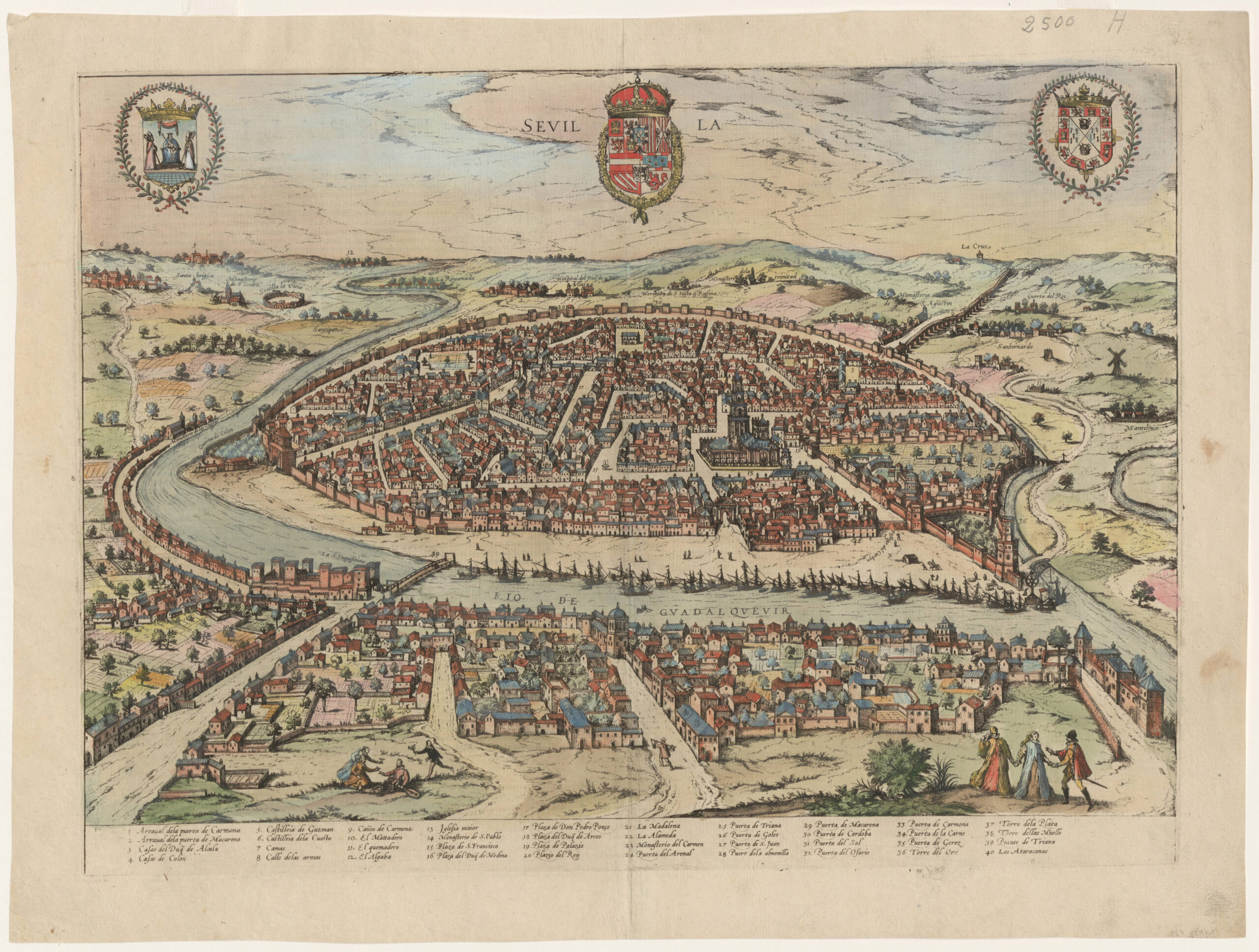
This map is a view of Sevilla, one of the most important cities in Europe at the time of publication. It shows “Sevillanas” in local dress and features a detailed legend describing all of the entry points to the city. Of note are the Puerta de la Carne, or “meat door,” that is situated directly in front of the “matadero,” the slaughterhouse (one of my favorite urban development features). Also prominently featured are “La Giralda” cathedral with a Moorish minaret and the “Cuarta de Colon,” or Columbus’ quarters on the outer walls of the city. You can also see the castle where the Spanish Inquisition carried out their tortures in the name of Christ on the opposing shore of the Rio Guadalquivir. The “Torre de Oro” was used to block the river from invading forces with chains, as all of the gold from the New World made its way up the 90 mile river from its entry point in the Mediterranean Sea.
The plans, each accompanied by Braun’s printed account of the town’s history, situation and commerce, form an armchair traveler’s compendium, which the scholar Robert Burton in The Anatomy of Melancholy of 1621 asserted would not only provide instructions but would uplift the spirit as well.
It was truly the pre-commercial transit version of a coffee-table book.
My Connection: My first introduction to Spain was through an exchange program in high school, where I lived with a family in Cordoba, a neighboring city in Andalucia and we made several visits to Sevilla. When I moved to Spain as a consultant in the early 1990’s, I spent about four months working on a strategic plan for the Autoridad Portuario de Sevillla (Port Authority). I loved working on this project because I was able to think about how to take a port that had been the entry-point for all of the wealth from the New World during Spain’s dominance and define a strategic path forward some 500 years later. I would walk through the port and imagine the old ships coming in with their gold and silver. Today, the port is but a shadow of its former self and is largely used to transport olive oil and agricultural products. Unfortunately for the Port of Sevilla, the major highways from Huelva and Cadiz have made the inland transport of goods faster and less expensive by truck.