
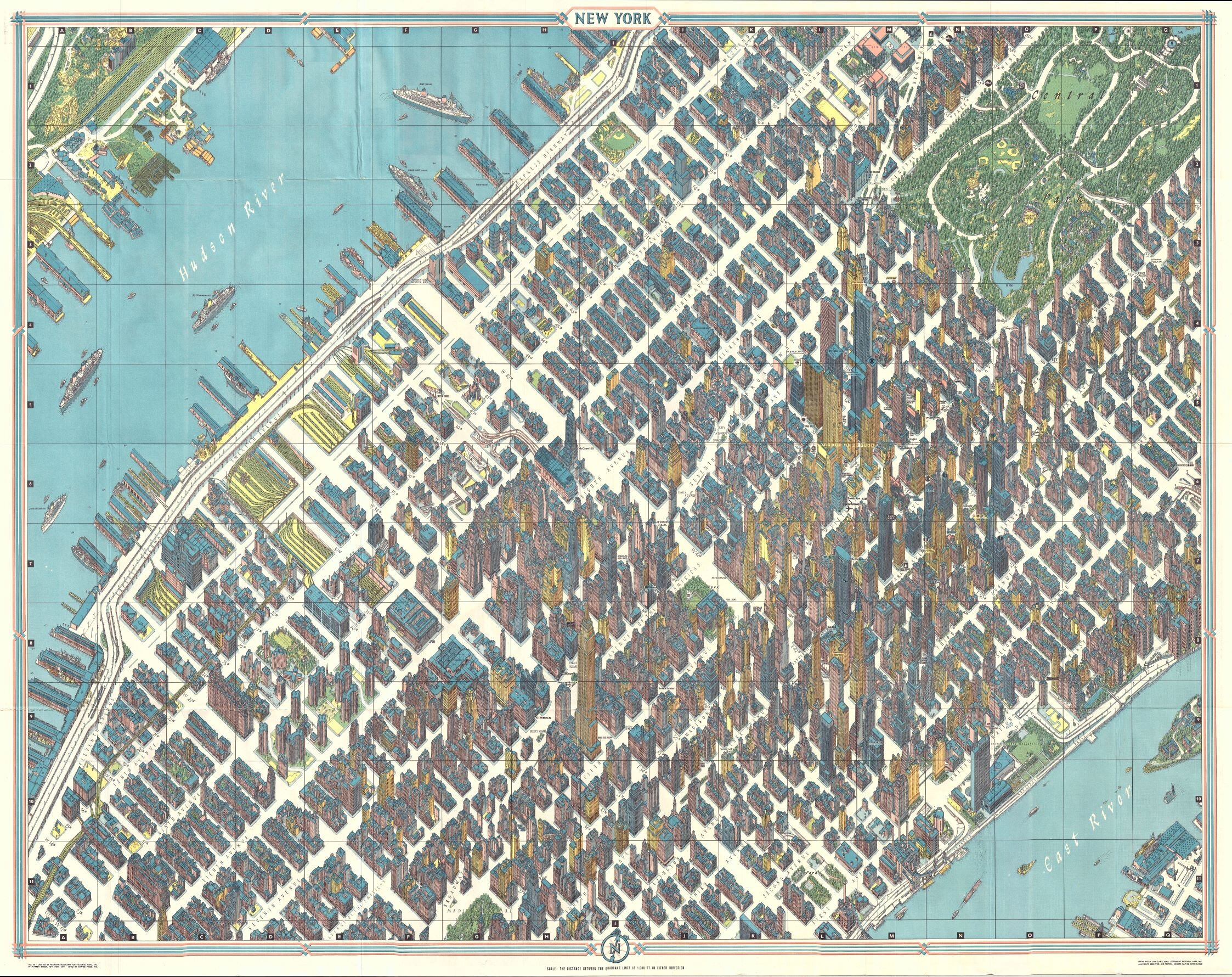
One of the greatest cartographic feats of all time, this 1963 axonometric (‘bird’s eye view’) map of New York City was the first such since 1866. The technique dates back to the 15th century, and developed in Germany into a fully flowered cartographic art form called Vogelschaukarten in Germany in the 1800s. This particular map was prepared by Herman Bollmann for the 1964 New York World’s Fair, where it was sold at information and tourist kiosks.
In making the map in the 1950s, Herman Bollmann and his staff faced a seemingly insurmountable problem, one never before encountered by his few predecessors in axonometric cartography: how to show New York’s many and densely concentrated skyscrapers from the same angle and relative height, while not obscuring most of the city behind them?
He and his team designed and built special cameras to take 67,000 photos, 17,000 from the air. Using these photos as a base, they then began to hand draw the entire city. Using then-secret cartographic techniques, Bollmann and team managed to depict the smallest details while simultaneously conveying the city’s soaring, vertiginous beauty.
The viewer is thus placed in the position of an Olympian God, a perspective that no other technologic and artistic form offers, even in the Internet age: with this map spread out before you, you have the ability to look upon any part of the city at will, down to its smallest detail, without waiting for a camera to pan or zoom or cut, without waiting for the next web page to load or zoom.
The guidebook– written in english, French, German, Spanish, Italian and Japanese– lists sights, hotels, restaurants and shops, making the work a valuable time capsule to a vanished city. One of the crowning glories of modern cartography, this stunning achievement is a must-have for those who love New York, bird’s eye view and the history of cartography.
known woodcarver and engraver based in Braunschweig, Germany. Following the war Bollmann developed a reputation as a printer of unique three dimensional maps. Working over a period of 25 years, Bollmann established a reputation as an artistic cartographer, producing over 39 unique projections of various cities in Europe and America. Bollmann revived the 19th century cartographic technique known as Vogelschaukarten, a way of making three dimensional axonometric projections. Bollmann and his team relied heavily on aerial cartography to compose distinctive cartographic masterpieces that are coveted by collectors all over the world.