
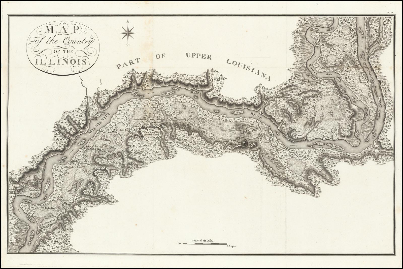
An important early map, with a fascinating history, showing the confluence of the Mississippi River, with the Missouri River, Illinois River and Kaskaskia River, from the explorations of General Georges Collot.
Collot’s map of the Mississippi River was compiled from his observations during his clandestine reconnaissance of the West on behalf of the French Government in 1796. The map shows the area near St. Louis, Missouri, which was then known as the ‘Country of the Illinois.’ The map provides tremendous details of the Mississippi River Valley from the Kaskaskia River in the South to the Illinois River in the north.
The map is extraordinarily detailed throughout being the finest map of any part of the Mississippi River of its era. It is perhaps the finest and most important early printed map of the greater St. Louis region, (St. Louis having been founded by French Canadian traders in 1764). Specifically, the map locates a number of early French and American towns, ruins, and businesses, and American Indian settlements, including Bourbon, St. Genevieve, Gabory, a ‘wooden fort’, Luzieres, numerous ‘salt works’, Kaskaskias (the first European village in the region), ‘windmills in ruins’, Fort Chartres (ruins), St. Philip, Hull’s Town, Sandy Meadows, Denis, New Design or Corne de Cerf, Fountain, Carondelet, St, Louis, Florissant, Marais des Liards, and St. Charles.
It also notes the remarkable ‘Indian Ancient Tombs’, or the Cahokia Burial Mounds, large funerary constructs built by the great Mississippian Native American civilization. Collot also meticulously details the roads, mountains, lakes, cliffs, swamps, the current of the Mississippi River and unnamed farmsteads.
The earliest French settlement in the area occurred in 1703, with the founding of the town of Kaskaskia (1703) and Fort Chartres (1718). At the conclusion of the French and Indian War, the area shown on this map was the most densely populated area of French settlement between the St. Lawrence Valley and New Orleans.
In 1763, the territory west of the Mississippi River was ceded to Spain by France, while the lands east of the river were ceded to Britain. In 1783, the lands east of the Mississippi formally became territory of the United States, although American possession of the region was tenuous at best. The mainly Francophone inhabitants of the Mississippi Valley had little affinity for Anglo-American rule, and their frontier lifestyle made them virtually impossible to control.
It was in this context that the government of post-Revolutionary France, the ‘Directoire’, schemed to reacquire France’s lost American territories. The Directoire had an acrimonious relationship with both America and Spain, and the possibility of supporting an insurrection by the region’s Francophone inhabitants was considered by many to be a viable means for France to regain Louisiana and the Illinois Country.
In 1796, the Directoire charged General George Henri Victor Collot (1750-1805) with undertaking a reconnaissance mission to the Mississippi frontier, in order to assess whether the region could be retaken by France. Collot seemed like the perfect man for such an assignment. A former governor of Guadeloupe, he was an accomplished veteran of colonial service and an extraordinarily gifted mapmaker. He traveled from Pittsburgh down the Ohio River to the Mississippi, up the Mississippi to the Missouri and Illinois Rivers, and then back down the Mississippi to New Orleans. During his journey, Collot constructed a large number of exceptionally fine manuscript maps and views of the region that he traversed. Many of these were groundbreaking, containing never before recorded information on a wilderness that was just beginning to undergo settlement.
While Collot’s intellectual achievements were impressive, his mission was a political disaster. Collot was arrested at Fort Massac on the Ohio River by the American officer Zebulon Pike (himself soon to become a legendary explorer). Pike told Collot that “you have been indefatigable in surveying the Ohio, by taking the courses, distances, heights, etc., as well as reconnoitering the adjacent area for which you exhibit no authority”. While he was well aware that Collot was a French agent-provocateur, the officious Pike set him free, as he could not find any legal means of detaining him. Collot was, however, later shadowed by Spanish agents and arrested and deported as soon as he arrived in New Orleans. Fortunately, the Spanish governor allowed Collot to retain his maps and papers.
Louisiana and the lands west of the Mississippi were returned to France by Spain in 1800, and Collot hoped that this would only increase interest in his work, however this was not to be. Unfortunately for Collot, in 1803, the new French dictator, Napoleon Bonaparte, decided to sell Louisiana to America. While Collot’s maps were engraved on copper in Paris in 1804, their publication was suppressed by the government so as not to trouble American sensitivities. As a result, the plates were not printed until 1826, when they were issued in a limited number as Voyage dans l’Amerique Septentrionale, consisting of an atlas and text volumes in both French and English text.
Rarity
The map is very rare, as is the book in which it was published. It has been noted that “A nineteenth-century bookseller called this work ‘one of the most famous, most important, and rarest of all books of Mid-Western Explorations.’
Its rarity is due to the deliberate destruction of all but three hundred French and one hundred English copies by the publisher, who had purchased the edition from Collot’s estate, hoping to increase its value” (Cohen).